


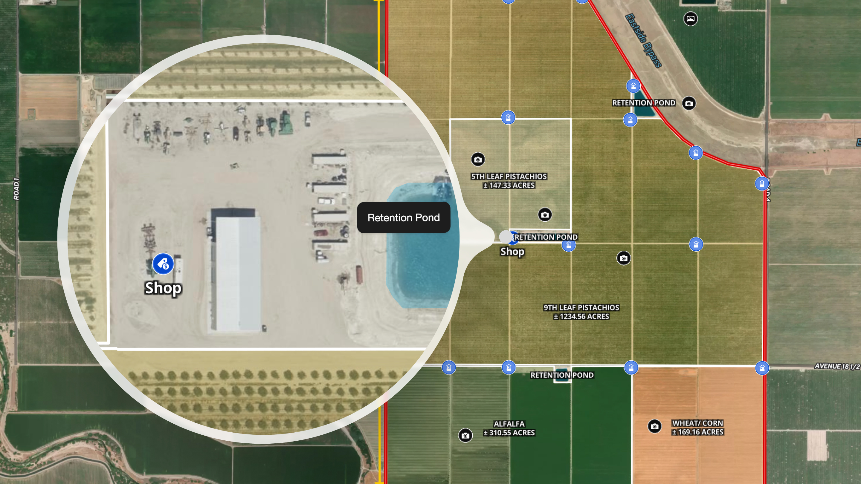
Farm aerial imagery gives agricultural professionals the ability to assess land conditions, verify infrastructure, and make informed decisions without spending hours driving between properties. High-resolution overhead photography—captured at 30 centimeters per pixel or finer—reveals fence lines, water sources, timber stands, and field conditions that standard satellite maps blur into uselessness.
For farmers, ranchers, land managers, and ag real estate professionals, the difference between consumer-grade satellite imagery and professional aerial imagery isn't academic. It's the difference between spotting a failing irrigation pivot from your office and discovering it after the crop damage is done. It's seeing that the "improved pasture" in the listing is actually 40% cedar encroachment before you waste a four-hour drive.
This guide covers what farm aerial imagery is, how it's captured, what you can actually assess with it, and how to access professional-grade imagery without expensive standalone subscriptions.
What Is Farm Aerial Imagery?
Farm aerial imagery refers to high-resolution overhead photography of agricultural land, captured from aircraft or advanced satellite systems at resolutions that reveal individual structures, equipment, and land features. Unlike the blurry satellite views most people are used to from consumer mapping apps, professional-grade aerial imagery lets you zoom into a 500-acre ranch and distinguish a stock tank from a shadow.
Resolution is measured in centimeters per pixel—the smaller the number, the more detail you can see:
- 1 meter (100cm): See large buildings and major roads—enough for a general property overview.
- 30cm: Identify individual structures, vehicles, large equipment, pivots, and ponds.
- 15cm: Make out fence lines, small structures, and tree canopy to assess fencing, timber, and signs of erosion.
- 7.5cm: See fine details like individual fence posts, irrigation lines, and crop rows for a closer look at property infrastructure.
Where Farm Aerial Imagery Comes From
Professional aerial imagery is captured through three primary methods:
Aircraft flights remain the gold standard for agricultural imagery. Fixed-wing aircraft equipped with specialized cameras fly systematic patterns, capturing overlapping images that are later stitched into seamless basemaps. Land id®'s high-resolution imagery comes from over 100,000 flights and hundreds of millions of individual images—the kind of coverage that reveals what's actually happening on the ground.
Satellite systems have improved dramatically, with commercial satellites now offering sub-meter resolution. However, satellite imagery often suffers from cloud cover issues, atmospheric distortion, and less frequent update cycles in rural areas.
Drone capture provides the highest resolution possible but is limited to small areas and requires on-site operation. It's excellent for targeted assessment but impractical for evaluating multiple properties or large acreages.
The Problem With Standard Map Imagery
If you've ever tried to zoom into a rural property on Google Maps or Apple Maps and watched the image turn into a pixelated mess, you've experienced the core problem. Consumer mapping services prioritize urban areas where most users live. Rural and agricultural land—the properties that actually need detailed imagery for assessment—often get imagery that's years old and barely detailed enough to distinguish a barn from a tree line.
For ag professionals, this isn't just inconvenient. It's expensive. Every site visit to a property that doesn't meet your criteria costs fuel, time, and opportunity. Every listing you can't properly evaluate remotely is a potential deal you lose to someone who can.
Why Resolution Matters for Agricultural Assessment
The practical value of high-resolution imagery comes down to what you can actually see and assess without being physically present. For agricultural properties, that list is extensive.
Assessing Timber & Vegetation
At 30cm resolution or better, you can evaluate:
- Timber stand density and health—Distinguish individual tree canopies, identify gaps in coverage, spot areas of die-off or disease
- Cedar and brush encroachment—See exactly how much "improved pasture" is actually being lost to invasive species
- Riparian vegetation—Assess the condition of creek and river corridors, identify erosion risks
- Crop coverage and field conditions—Verify what's planted, spot irrigation issues, identify problem areas
A rancher evaluating a potential purchase can see whether that "200 acres of native grass" is actually 120 acres of grass and 80 acres of mesquite. A timber investor can estimate board feet without hiring a forester for the initial assessment.
Evaluating Water Resources
Water infrastructure is often the make-or-break factor for agricultural land, and it's precisely what high-resolution imagery reveals:
- Stock tanks and ponds — See actual water levels, assess dam condition, identify siltation
- Creek and river access — Verify water frontage claims, assess bank stability, spot potential flood zones
- Irrigation infrastructure — Identify pivot locations, verify coverage patterns, spot malfunctioning equipment
- Drainage patterns — See where water flows across the property, identify potential wet areas or drainage issues
Verifying Fencing & Infrastructure
Fencing represents a massive investment on any working ranch or farm. At 15cm resolution or better, you can:
- Trace fence lines — Verify that fencing matches the property boundaries and sales descriptions
- Identify cross-fencing — See how the property is subdivided for rotational grazing or livestock management
- Spot gaps and repairs needed — Identify sections where fencing appears to be down or in poor condition
- Assess working facilities — Evaluate corrals, loading chutes, barns, and other improvements
Identifying Structures & Improvements
Beyond fencing, high-resolution imagery reveals the full picture of property improvements:
- Outbuildings and equipment storage — Count barns, sheds, and covered areas
- Residential structures — Assess condition of homes, guest houses, and worker housing
- Roads and access points — Verify that access roads exist and appear maintained
- Utilities — Spot power lines, propane tanks, and other utility infrastructure
High-Res Aerial Imagery: Real-World Applications for Ag Professionals
Different agricultural professionals use aerial imagery for different purposes, but the core value is the same: see more, drive less, decide faster.
For Ranchers & Farmers
Working operators use aerial imagery to:
- Monitor their own land — Spot changes in vegetation, water levels, or infrastructure condition without driving every fence line
- Evaluate expansion opportunities — Screen potential purchases or leases before committing to site visits
- Document conditions — Create visual records for insurance, estate planning, or lease negotiations
- Plan improvements — Identify optimal locations for new fencing, water infrastructure, or facilities
For Land & Ranch Real Estate Professionals
Land brokers and agents specializing in agricultural properties use aerial imagery to:
- Pre-screen listings — Verify that properties match descriptions before taking them on
- Create compelling marketing materials — Show buyers exactly what they're getting with imagery that reveals the property's true character
- Answer buyer questions remotely — Address specific concerns about fencing, water, or improvements without scheduling additional site visits
- Price properties accurately — Assess actual conditions and improvements for realistic valuations
For Agricultural Lenders & Appraisers
Financial professionals use aerial imagery to:
- Verify collateral condition — Confirm that land and improvements supporting loans match documented descriptions
- Identify risks — Spot environmental concerns, encroachment issues, or condition problems that affect value
- Streamline inspections — Reduce the number of physical inspections required for routine monitoring
- Document assessments — Include visual evidence in appraisal reports and loan files
For Land Managers & Consultants
Conservation professionals, range consultants, and land managers use aerial imagery to:
- Assess baseline conditions — Document current land state before implementing management changes
- Monitor progress — Track the results of brush management, grazing plans, or restoration projects over time
- Plan treatments — Identify specific areas for prescribed fire, mechanical treatment, or other interventions
- Report to landowners — Provide clear visual documentation of management activities and results
How to Get Professional-Grade Farm Aerial Imagery
Historically, accessing high-resolution aerial imagery for agricultural properties meant either expensive subscriptions to specialized providers or hiring pilots for custom flights. Neither option made sense for individual farmers, ranchers, or even most real estate professionals.
Traditional Options & Their Limitations
Government sources like USDA's National Agriculture Imagery Program (NAIP) provide free imagery, but resolution is typically 60cm to 1 meter—good for general overview, not detailed assessment. Updates happen every few years at best, and coverage timing varies by region.
Specialized imagery providers offer higher resolution and more frequent updates, but standalone subscriptions often run hundreds to thousands of dollars per year. For a rancher evaluating one or two properties a year, the math doesn't work.
Custom drone or aircraft flights provide the highest quality but require scheduling, weather cooperation, and high per-flight costs. They're appropriate for final due diligence on major acquisitions, not routine property screening.
Accessing High-Resolution Aerial Imagery Through Land id
Land id integrates high-resolution aerial imagery directly into our property intelligence platform, eliminating the need for separate subscriptions or technical setup. The imagery—sourced from over 100,000 flights and hundreds of millions of images—is available as a basemap layer that you simply toggle on.
Here's what that means practically:
- No separate subscription — High-resolution imagery is included with Land id Premium and Pro plans.
- No technical setup — The imagery is a basemap option, not a separate system to configure.
- Integrated with parcel data — See property boundaries, ownership information, and high-res imagery together.
- Works with other Land id tools — Use the measure tool, draw features, plan setbacks with the buffer tool, and share interactive maps that include the high-res imagery.
Coverage is currently focused on high-density regions, with new areas added regularly. For rural and agricultural properties—where standard map imagery is least useful—we prioritze expanding coverage to the areas that need it most.
Practical Tips for Using Farm Aerial Imagery
Having access to high-resolution imagery is only valuable if you use it effectively. Here's how to get the most out of it.
Before Evaluating a Property
- Check imagery date — Know when the imagery was captured so you can account for seasonal differences or recent changes.
- Understand resolution limits — Even high-res imagery won't show everything; know what's visible at your resolution level.
- Have comparison imagery available — Historical imagery can reveal changes over time that single snapshots miss.
During Property Assessment
- Work systematically — Don't just scan randomly; trace fence lines, follow water features, inventory structures.
- Use measurement tools — Estimate distances, areas, and feature sizes rather than just visual impressions.
- Document what you see — Save screenshots, create annotated maps, or share findings with colleagues and clients.
- Note what needs field verification — Some things can only be confirmed on the ground; prioritize your site visit time.
For Listings & Marketing
- Choose representative views — Select imagery angles that show the property's best features accurately.
- Annotate key features — Label water sources, improvements, and boundaries on shared maps.
- Use interactive sharing — Send clients links to explore the imagery themselves rather than static screenshots.
- Combine with other data — Layer parcel boundaries, topography, and other information for complete context.
Conclusion
For agricultural professionals—whether you're running a cattle operation, brokering farm and ranch sales, or managing land for clients—high-resolution aerial imagery has shifted from luxury to necessity. The ability to see fence lines, water infrastructure, timber conditions, and property improvements without driving hours to a remote parcel changes how you evaluate opportunities, market properties, and make decisions.
The question isn't whether you need this capability. It's whether you're still working without it while competitors aren't.
Land id brings professional-grade aerial imagery together with parcel data, mapping tools, and the sharing features that make your research useful—not just to you, but to your clients and colleagues. No separate imagery subscription. No technical setup. Just the detail you need, where you need it.
See the difference for yourself. Explore sample high-resolution imagery and discover what you've been missing in standard satellite views.
Ready to upgrade your property research? See Land id plans and pricing →
FAQs
How current is farm aerial imagery compared to what I see on Google Maps?
Can I use aerial imagery to estimate timber volume or crop yields?
Is aerial imagery accurate enough for fence line disputes or boundary questions?
How does weather affect aerial imagery quality?
Can I access historical aerial imagery to see how a property has changed?
What's the difference between aerial imagery and satellite imagery?
Catch Deal-Breakers Early
Save time and avoid expensive mistakes. Use Land id to evaluate deal-killing constraints before you leave your desk.
Continue Reading
Craig Rowe
Real Estate’s Super El Niño Problem


By Land id
Just some rain...or real estate catastrophe? With months before winter hits, some states are already feeling the effects of this year's so-called Super El Niño. Here's how agents can help their clients.

Craig Rowe
How to Work With Out-Of-State Buyers: Tips for Real Estate Agents
By Land id
Agents in emerging markets will benefit from an influx of aspiring buyers. Get tips on how to make the most of these potentially lucrative leads.

Explore Private Parcel Data & Property Boundaries
Download the Land id app and try for free.


